Tajikistan: Flagging up a nation on the edge
October 24, 2013 -
Stuart Wadsworth
-  Bez kategorii
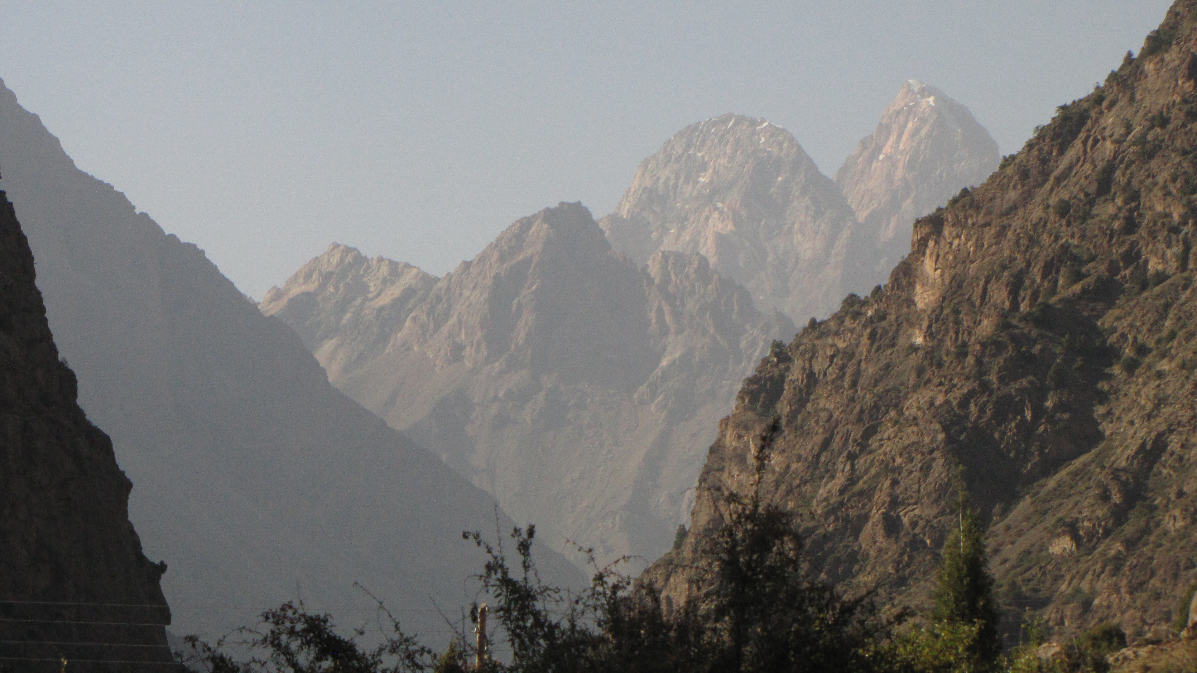
mountains 4.JPG
Having recuperated from a combined bout of altitude sickness and food poisoning for a few days in the relative civilisation of Khorog and its stunning environs, and having had the luxury of a hot shower and a couple of decent meals, it was time to leave the Pamir Mountains. If getting into the Pamir had been a difficult job, getting out of them again was to prove equally, if not more, problematic.
Khorog lies some 300km to the south-east of Dushanbe as the crow flies, and the easiest (and perhaps sanest) way to get there is by plane: locally known as the “Badakhshani Express”. This option offers a short but exhilarating 45-minute ride brushing the snow-flecked peaks of the Pamirs, sometimes quite literally. The average altitude the unpressurised planes fly at on this route is 4200m; peaks exceed 5000m. During Soviet times, this route was the only one for which Aeroflot offered its pilots danger money, although to its credit the only recorded fatalities occurred on this route came courtesy of a surface to air missile from Afghanistan. Flights are cheap (around 100 dollars), but usually booked weeks in advance for the 40-seater plane, and at the slightest hint of bad weather the flight is cancelled.
Along the Pamir
Thus, I was obliged to continue the hard way along the remainder of the Pamir Highway, overland. By road, it’s more than 500km of the worst section of motorable road in Tajikistan, possibly all of Central Asia. There are no bus services and a place in a jeep shared with five others costs around 60 dollars per person. Unable to face the prospect of up to 20 hours in a teeth-rattling Lada Niva, I decided to break the journey at Khala-i-Khum. The valley was now more enclosed, the grey-brown rocky peaks rising steeply on either side, the road following a narrow ridge above the river which, when passing other vehicles, was highly precarious, but made for thrilling driving. In places, Afghanistan is so close that people can be seen in front of their small mud huts, colourful carpets hung out to dry and children playing in the streets. It’s a strange feeling to be so close to a country that seems so remote and impossible to get to, and which most of us have only seen on the news.

The road passes the Bartang Valley, which eventually leads up to Lake Sarez, perched high in the central Pamir. Said to be spectacular, though extremely inaccessible, Sarez presents one of the biggest potential natural disasters in the world. Formed in 1911 by an earthquake which dislodged an entire mountainside into the path of the Murghab River, the lake is a ticking time-bomb. If another earthquake of similar magnitude occurred, removing the plug that has formed the lake, it would cause a flood of biblical proportions, destroying everything in its path, not just in Tajikistan but deep into Uzbekistan, Turkmenistan and Afghanistan. It would be the biggest flood ever witnessed by human eyes. Ironically, most of the above-mentioned countries have problems with low rainfall, period crop failure and occasionally, drought.
Khala-i-Khum was literally a place to bed down for the night. Arriving late and exhausted, sleep came immediately upon arrival at a guesthouse populated almost entirely by cyclists traversing the Pamir Highway, most of whom looked understandably frazzled. It served its purpose though, and it meant that I saw the entire Pamir in daylight – it would be a shame to travel it by night, not to mention rather worrying to have to rely on a caffeine and tobacco-fuelled driver to remain alert on such a punishing journey. The final day was the most testing, partly due to several days spent bumping along its gruelling length, and partly due to frequent stops for petty bribes by roadside police.
 Additionally, this section of the route is the most pot-holed, and I spent most of the journey smacking my head against the ceiling and gripping the door handle. The dust from the road coming in the open window was so bad that I later found I had an eye infection. When the car hit a metalled road at Dangara in the late afternoon it came as something of a shock, and the (relatively) smooth road for the rest of the journey to Dushanbe felt like luxury. The splendid turquoise waters of the Nurek reservoir an hour or so south of Dushanbe was the scenic highlight of the day. Arrival at Dushanbe capped a trip of over 40 hours and 1200km from Osh, although I was too tired to feel elated. The Pamir Highway was finally over, I found myself deposited and a bit bewildered in a grey and drab Communist-era hotel on the outskirts of the city.
Dushanbe
Dushanbe, in common with other Central Asian capital cities, is a fairly bland and functional, if generally agreeable, green and pleasant city, which lacks any memorable sights. It was the first settlement of any real size I had come across in Tajikistan, and with a population of under 600,000, is still more than three times larger than the second city, Khojand. Dushanbe means Monday in Tajik, which is market day, and as recently as 80 years ago it was no more than a small, poor village known mainly for its bazaar. Wandering a few blocks off the main drag, it still feels very provincial indeed, with farm animals roaming the streets and locals chatting or dozing over cups of tea and plates of plov in their gardens. It is anything but a pretentious capital. Nevertheless, arriving there was a shock after the extreme poverty of the countryside, and having such luxuries as internet, (albeit intermittent) hot water and a few modest restaurants was a novelty.

The residence of President Emomalii Rahmon is here, and most of the notable buildings are on or near the main drag Prospekt Rudaki, including the palatial Palace of Nations, complete with extensive gardens and the tallest unprotected flagpole in the world. Standing at an impressive 165m, it beats Azerbaijan’s National Flagpole and Turkmenistan’s Ashgabat Flagpole. Costing 3.5 million dollars to build in 2010 as part of the 210 million dollars spent on lavish projects celebrating the country’s 20th anniversary of independence, many observers have sharply criticised the government for splashing out over a tenth of the annual national budget on the occasion, particularly when the country is already deeply in debt.
The president also caused great resentment amongst the city’s Jewish community by destroying its last remaining synagogue, a fine 19th century building, to make way for the new palace. Local dissent has largely been muted through harassment by the authorities. White elephant projects are common in this part of the world, perhaps no more so than in nearby Turkmenistan where erstwhile President Saparmurat Nyazov is infamous for having erected gold statues to himself around the capital that rotate to face the sun, amongst countless other follies. While Rahmon is slightly more low-key, funding such projects in a country which is largely in a state of dire poverty, with most of its citizens living under the breadline, is questionable to say the least.
The tunnel of death
Unfortunately, improvements to the infrastructure remain limited mainly to Dushanbe, and this is felt almost as soon as one leaves the city. The road north to the Fan Mountains is fine until the road reaches the Anzob Pass, 80km north of Dushanbe. Until recently, no passable road existed along this route during the winter months and traffic to Khojand was obliged to take a route through Uzbekistan. With no borders between the countries before 1991, this used to work, but relations after the break-up of the Soviet Union deteriorated badly, and if the Uzbeks decided to close the borders, Tajikistan was essentially divided into two parts for half the year.
 A solution to this intractable problem was found when the Iranians, close ethnic relations of the Tajiks, agreed to build and partly fund the Anzob Tunnel, a 100-million-dollar, 5km construction through the mountains below the Tajik town of Anzob. Initially dubbed a symbol of friendship between the two countries, since completion in 2006 it has been anything but. Unpaved for its entire length, the tunnel is unlit, frequently flooded, badly ventilated and downright dangerous. It has become known locally as “The Tunnel of Death”, since tragic accidents often occur when people are killed due to traffic and build-up of exhaust fumes which, unable to adequately escape the ill-ventilated system, cause carbon monoxide poisoning. Cyclists wishing to pass through the tunnel must sign waivers stating that the authorities are not responsible for injury from falling rocks.
When I passed through the tunnel, there were puddles over half a metre deep in the middle of the tunnel and water gushing down the walls. Machinery stood around, inert, as if workers had disappeared half-way through the job. I silently prayed our car wouldn't break down. Thankfully, it didn’t. The situation is so bad that various new contractors have been brought in to attempt to rectify the design problems of the tunnel, although currently it seems no solution can be found other than simply abandoning the tunnel and building a new one. The tunnel is a tragic symbol not only of the slap-dash way in which projects take place in this part of the world, but also of the new Great Game in the region, where companies and countries fight over the right to build roads, bridges and tunnels as cheaply as possible at the cost of safety – a geopolitical fight for influence over the region between Iran, China, Russia and the United States, amongst others.
Turquoise lakes and freezing streams
Arriving at Iskander-Kul in the Fan Mountains in late afternoon after a great deal of hanging around waiting to get a hitch (there still being no public transport at all), I was taken aback by the stark beauty and serenity of the surroundings. The turquoise-blue lake, surrounded on all sides by monolithic stone peaks, is a small gem of Central Asia, virtually unvisited by tourists and eerily silent except at weekends when it occasionally gets invaded by party-goers from Dushanbe.
 Iskander-Kul means Alexander’s Lake, and it was here that Alexander the Great is said to have passed through on his way to India. It is unlikely he would have found a much more agreeable lake between here and Macedonia, although perhaps his native Ohrid comes close. The lake however is not much use except as an exceptionally photogenic subject; fed by freezing mountain streams, it is too cold to swim, even at the height of summer. Also, due to its high mineral content, it contains no fish, which explains why it is so oddly bereft of life. At the far end of the lake, the president owns a summer residence, and the lake’s prize sunbathing spot is reserved for his infrequent visits. On these occasions, the road up to the lake is closed, even though he is flown in by helicopter, much to the inconvenience of locals.
After a couple of days relaxing and wondering round the area, the highlight of which was an impressive 38-metre waterfall known locally as Niagra, it was time to move on to a village above the lake called Sarytag. Perched at an altitude of over 2500m, the village had an outstanding location on a plateau below towering peaks, and made for a fantastic base from which to explore several valleys in the area. Local hospitality here was excellent – I stayed in an exceptionally welcoming homestay – and it was one of the best places I had been to sample local cuisine and to get to know the locals. Life here was as tough as everywhere else in Tajikistan, although there is no impression of desperation in the friendliness and genuine warmth of the people. The Tajiks are one of the most resilient people I had met, and have the knack of just getting on with life without much complaint – an admirable quality.
Grit your teeth and get on with it
My time in Tajikistan was almost up, but there was one more travel-related problem to deal with: my planned route to Uzbekistan, via Penjikent to the North – which would have taken me conveniently to Samarkand, a mere 50km beyond – was off the cards because the Uzbeks had closed the border. A political dispute between the two countries, I was told. This meant an aggravating 150km back-track to Dushanbe through the tunnel followed by a much more circuitous and time-consuming route to Samarkand from the South. It was a final reminder of what makes travel in this region of the world so unpredictable and so frustrating, but with no choice but to do as the Tajiks do and simply grit my teeth and get on with it. Tajikistan has that way of knocking you into shape, and I hoped that even if the country and its people had been an experience to treasure, Uzbekistan would provide some mental and physical relief.
Read the first and second report in this series. All photos are published with kind permission of Stuart Wadsworth, except Anzob Highway (Creative Commons)
Stuart Wadsworth is a freelance writer and travel photographer, and has contributed to Rough Guides, Urban Travel Blog, the Krakow Post and other media. He has a blog: http://www.offexploring.com/stuinkrakow. Stuart has spent the last decade travelling to, and writing about, Central and Eastern Europe, the Middle East and Central Asia, and has visited every country in the old Eastern Bloc. He calls Krakow his home for now and enjoys spending his spare time watching and reviewing live music, and in the summer escaping to the mountains. His career as a food critic was curtailed due to an expanding waistline.