The failure of mapmaking and territorialisation of statehood in Polesia and Belarus in 1918
For various reasons, the Brest-Litovsk Peace Treaty, signed on March 3rd 1918 between the Central Powers and Soviet Russia, was published without the agreed upon map. This insufficiency may have had dire consequences on the success of an independent Belarusian People’s Republic, which was later overtaken by the establishment of the Soviet Socialist Republic of Belarus in 1919.
Why was the map of the Brest-Litovsk Peace Treaty neither published nor handed down? It was an integral part of the binding international treaty that was adopted on March 3rd 1918. Instead of a written definition of the border demarcation, Article III of the treaty contained a fleeting reference to a map in the annex. The border was drawn according to a map kept in the Political Archive of the Foreign Office in Berlin since June 1918 at the latest. The original map is very large, on a scale of 1:800,000, and allowed the territorial assignment of places that are only ten kilometres apart. However, this graphic representation was never used.
November 5, 2018 -
Diana Siebert
-
History and MemoryIssue 6 2018Magazine
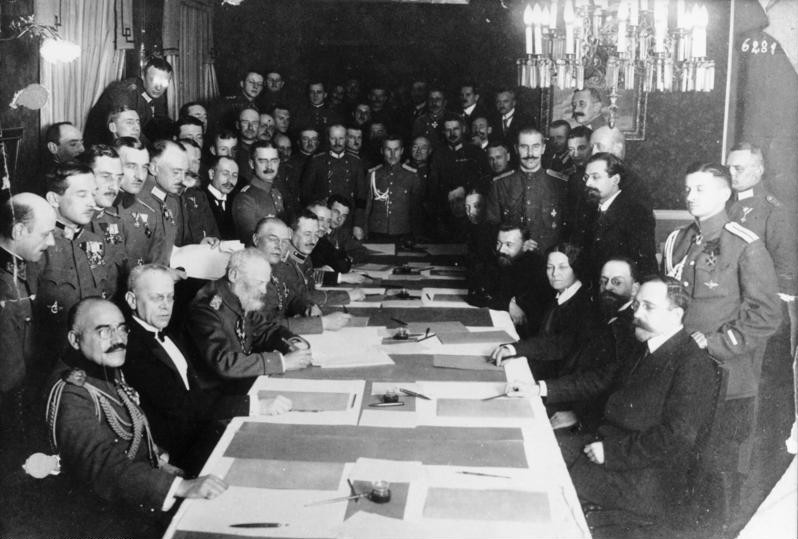
The signing of the Brest-Litovsk Treaty. Photo: German Federal Archive (CC) commons.wikimedia.org
The non-publication of the map raises the question as to its influence on historiography and the extra-historiographic reality. Given that the Belarusian People’s Republic (BNR) was established just a few weeks later (on March 25th 1918), the question remains whether this act would have been bolstered by greater visibility of the Brest-Litovsk agreements, even insofar as it would have made indirectly clear that there is an area which had not been discussed at the negotiating table in Brest-Litovsk.
Finding territory
Those involved in founding states at the end of the First World War had already internalised the modern Jellinek principle that “a state needs a territory”. The creation of corresponding maps was an external expression of this principle. Both the Ukrainian People’s Republic (UNR, which was declared in 1917 prior to becoming a part of the Soviet Union) and the BNR took this very seriously and were more concerned about the size of their territory than with developing their state administration. It is striking that the territorial consequences of the Brest-Litovsk agreement in March 1918 between the four Central Powers and Soviet Russia have until now often been represented by imprecise and incorrect maps. This is also because the original map was not published. There are various reasons for this.
First, a Belarusian territory, as a political space in the Central Powers’ plans, did not exist, not even as a geographical idea. At the time of the negotiations and the signing of the Brest-Litovsk treaty, there existed the area designated as Ober Ost (formed in 1915). From the outset this was a territorialised Land established by the German occupying forces according to purely geostrategic criteria, an over-bureaucratised occupied territory governed quite autonomously by its commander in chief (the Oberbefehlshaber Ost). Ethnic or religious criteria played no part in the demarcation of its borders. On the contrary, the Ober Ost space looks rather like a geographical semicircle around Königsberg. So the question is what did the German Reich intend to do with those occupied areas of Polesia and Belarus that did not belong to Ober Ost? The answer is that the occupying forces themselves did not know. There are different names for this territory even today: Jerzy Turonek called it the “operation area”, while Uladzimir Ljachoŭski termed it the “rear administrative district”. The fact that the German Reich representatives had made no firm efforts at territorialisation of Belarus was surely because it simply did not exist for them as a political and geographical entity.
The fact that the Central Powers did not recognise Belarus as a territory is contrasted by the case of Ukraine. There had been symbolic recognition of Ukraine as a territory and the Ukrainians (Little Russians, Ruthenians) as a “people”, particularly in Austria-Hungary and to a lesser extent in the German Reich since the times of Bismarck, prior to the First World War and then even more so during it. In negotiations with the representatives of the Ukrainian Rada (as the government of the UNR) at the start of 1918, at the request of the Habsburg Empire, the Central Powers avoided negotiating the issue of Ukraine’s western and south western border officially so as not to question the territorial integrity of the Habsburg Empire in its pre-war boundaries. The UNR itself had given priority to expanding its territory from the outset.
About the future Ukrainian north western borderline there were, by contrast, official negotiations of two very different types. While on border demarcation in the region of Chełm there was a heated yet diplomatic debate among the Ukrainian, Polish and German speaking public, the border in Polesia was negotiated between the Central Powers and the Rada of Ukraine almost parenthetically. The negotiating partners were able to reach an agreement quickly over western Polesia, unlike the case of Chełmszczyzna. Firstly, this was because the third parties (Belaruskaya Rada, Soviet Russia) were very weak political entities in these times, and secondly because the negotiators for the Central Powers had limited knowledge of the geography and history of Polesia. Even the name “Polesia” was not familiar to the German and Austro-Hungarian occupying forces, so they called the west Polesian area the “Rokitno Marshes”. Hence, in a relatively relaxed discussion on January 19th 1918 the Central Powers agreed with the Ukrainian Rada and UNR on the borderline and established it in the treaty of February 9th 1918. Western Polesia was handed over to Ukraine.
Strategically unimportant?
Representatives of the hastily established BNR, which also laid claim to Polesia, now had to negotiate with UNR representatives on this region. But was Polesia really less important than Chełm? The Ukrainian Rada desired both irredentist aims. For the Ukrainians, though, it was not about Polesia, but about what they considered Ukrainian-speaking areas.
Similarly, the Polesia and Belarus issues seemed to be treated as almost unimportant in the ongoing negotiations between the Central Powers and Soviet Russia. In contrast to the question of Ukraine and the Baltic provinces of Estonia and Livonia, which were the subject of fierce debate in the German Reichstag, there was almost no dispute between the negotiating partners on the issues of Belarus and Polesia. The Soviet delegation recognised the February border in western Polesia, and in the March treaty there was a cursory stipulation that the UNR and “Russia”, as it was called throughout the contract, would have to agree on the course of the borders for east Polesia, and generally the northern and eastern borders of Ukraine. So the territories of neither Polesia nor Belarus were subjects of the negotiations as political entities. Thus, we could speak about the failure of territorialisation of both Belarus and Polesia.
Secondly, there was another important reason for the non-publication of the map: representatives of both Soviet coalition partners in Petrograd – the Bolsheviks and the party of Left Social Revolutionaries – placed little value on the territorial and geostrategic questions during the negotiations. From the outset there was an ambiguous foreign policy by the Soviets that was nominally designed to bring down the “old” dynastic as well as “new” republican states from below –from the inside, not the outside. It is known that the Soviet delegation in Brest-Litovsk used the public negotiations to disseminate their propaganda calling for world revolution. But the demand for peace without annexations (and contributions) sounded very territorial.
And yet, for the Bolsheviks at this stage, the right of self-determination they proclaimed for other countries turned out to be purely tactical: the party’s “proletarian” rule within their own country did not know self-determination. But now, as the borderline had to be determined and hence territorialised in the progressing negotiations, the Soviet representatives also agreed to define the “Russian-Ukrainian” border only as far as Lake Vyhanaščanskaje and to leave its course eastwards open. The negotiators also agreed in Article III of the March 3rd 1918 treaty on the border demarcation (as described above) between the two spheres of influence.
A third reason is that the provisions of Brest-Litovsk were embarrassing for relevant political forces in the German Reich. In Berlin it was clearly noted that in Estonia and Livonia different zones of influence were assigned to the mainland on one hand and their islands on the other. The map of Brest-Litovsk includes distribution of spheres of interest between Germany and Soviet Russia, but contrary to the Reichstag’s Peace Resolution in 1917, it outlined possible annexations – the Ober Ost region in particular. A look on the map proves this very clearly. Furthermore, the publication of the map would have shown that there had to be a retreat of the German Army from the trenches and a relinquishment of Belarusian territories around Njasviž, Baranavičy and Ašmjany, territories where German soldiers had been for over two years.
More about peace than treaty
Fourthly, this map was extremely awkward for the Bolsheviks and the Left Social Revolutionaries who were also present at the negotiating table. Vladimir Lenin had not even submitted the text of the treaty to the delegates of the Soviet Congress, let alone the map. Yet, more delegates voted against the treaty than the number of the opposing Left Social Revolutionaries representatives at the Soviet Congress. But popular support for the contract was high. For the population in the ruins of the Russian Empire at the beginning of 1918, the word “peace“ in the peace treaty was more important than the word “treaty”. Lenin understood this acutely. For the Bolsheviks – avowedly or not – the central notion was that “their” state was now diplomatically recognised by the treaty, wherever its boundaries with Belarus or Polesian swamps would be. The fifth point is that there were technical and organisational reasons for the non-publication of the very big and colourful map.
But why has the map attracted so little attention in contemporary discussion and why did it remain neglected by historians in the archives? It may be that the cartographic interest was short lived because the treaty had already been rendered invalid with the November 11th 1918 Armistice of Compiègne – which brought not only an end to the war in Western and Central Europe, but also the existence of new states onto a new Eastern European map.
Nevertheless the March 1918 map is relevant because the border demarcations arising from the de jure recognition of the Ukrainian People’s Republic and Soviet Russia by the Central Powers resulted in some territorialisation. The criteria for this were not linguistic or ethnographic. In the case of Ukraine it had been unwanted mostly by Austria-Hungary, and in the case of Belarus the problem had been ignored or not even recognised. The non-publication of the map was, so to speak, successful, because later almost no one in Germany or Austria – as well as in the Soviet Union – knew the location of the borderline specified in March 1918. So it was not clear to contemporaries, let alone to posterity, whether the non-withdrawal of the Central Powers’ forces after March 3rd 1918 in the mentioned western Bela-Ruthenian area, and the advance of the German forces which began on February 18th and even continued after March 3rd, was lawful or not, nor whether they should have moved out of the occupied territories in Belarus. This ignorance and the resulting inaccuracies continue into present day cartography and historiography.
Colonial paradox
The publication of the map from the Brest-Litovsk treaty would have provided visual evidence that the Prussian-influenced German rule was divided over what to do with the conquered territories. This was because there existed what I call the Prussian-German colonial paradox. Prussia had become great by increasingly exerting direct rule over its subjects who were less and less divided into estate entities – in a constitutional state without democracy. Prussia, subsequently Germany, had no experience with indirect or intermediary rule, with domination without annexation, as practised by the Western European powers from Great Britain to Portugal in their overseas colonies; neither did the Eastern and Southern European land empires – the Habsburg, Ottoman and Russian Empires with their partly direct, partly indirect rule over there adjacent “colonies” – provide a blueprint. This Prussian will for direct rule led to an unwillingness to establish colonies and thus even hindered the German Drang nach Osten into non-German areas.
While the Oberste Heeresleitung and the Oberbefehlshaber Ost wanted to annex their Land Ober Ost as well as a big border strip called Randstreifen in the then-northwestern Polish territories, the fractions represented in the Reichstag by the political left and the centre increased their votes for the creation of a German nation state to prevent trouble with potential ethnic minorities. In their eyes, the borderline of the March treaty, which carved up the ethnic homelands of Belarusians, Latvians and Estonians, could have caused only unrest within Germany.
Even the representatives of Austria-Hungary, experienced with indirect rule, had only one reason why they finally participated in the invasion of Ukraine on February 28th 1918: they did not want to leave the confiscation of grain to the German Reich alone. Other than that, the decision-makers of the Habsburg Empire did not know what to do with the country. A territorial entity called Belarus was not negotiated in Brest-Litovsk, and the Belarusians were barely considered a people. Ironically, it was this geostrategic (and, as I call it, geographistic) approach that made Belarus disappear because the region, which the Central Powers would have had to vacate, could remain ignored and unmarked in the German-speaking space throughout 1918. If the “White Russians” or “White Ruthenians” were mentioned in German publications at all, it was almost always merely as one of the many ethnic groups in the region. The BNR, after its establishment in March 1918, could be largely ignored in Germany not only for the familiar reasons but also because it went almost unnoticed by the public that the German armed forces did not retreat from, but reconquered a large part of, Belarusian territory.
The regime of the Russian Soviet Federative Socialist Republic, subsequently the Soviet Union, capitalised on this situation. In recent historical studies the establishment of the Soviet Socialist Republic of Belarus (SSRB) in 1919 has mostly been portrayed as a concession, as a reaction to the declaration of the BNR. But moreover, for the Soviet Union, after the failed experiment of the short-lived Lithuanian-Belarusian Soviet Socialist Republic, the SSRB had become an ideological trump card over the Middle East and west European states. Belarus mattered. The reasoning for its existence was consistent with the Wilson Doctrine and the associated nation-state principle and it could be brought forward against the Second Polish Republic. It provided not only a justification but a significant ideological advantage in the dispute with the White Guards and the “foreign invaders”, as it did throughout the interwar period. The results in 1939 are well known.
The author would like to thank Felix Ackermann for his assistance in the publication this text.
Diana Siebert is a scientific associate of history at the University of Siegen (and lives in Köln), Germany.


