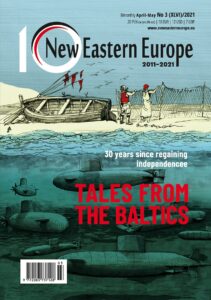
Tajikistan: The troubled roof of the world
October 17, 2013 -
Stuart Wadsworth
-  Bez kategorii

ram.JPG
Ask where Tajikistan is to the average member of the public and they will give you a blank look or bewildered shrug of the shoulders; even to Russians, for whom it was once a member of their empire, it is very little-known. Tajikistan was the poorest republic of the old Soviet Union, and today it is the poorest republic to have emerged from its break-up; so in that respect very little has changed. A savage civil war followed independence and raged on through most of the 1990s, and since then the road to peace and relative normality, like most of the roads in this country, has been far from smooth.
My road from Osh in Kyrgyzstan to Dushanbe, the capital of Tajikistan, was set to be one of the roughest I had ever experienced – comparable only to the atrocious roads in Ethiopia – along the M41 or Pamir Highway, the second-highest road in the world, reaching 4,655 metres and spanning some 1,100 km along some of the most bleakly stunning mountain scenery in all of Asia. Having secured a Tajik visa in Bishkek without too much fuss (75 dollars for 4 weeks) – and a permit for the autonomous Gorno-Badakhshan region (free) – I was looking forward to this part of the trip with trepidation and excitement.
Snowcapped peaks and petty bribes
The Pamir Highway is a bit of a misnomer as it is actually little more than a rough track for most of its length – the majority of it is unpaved, and this can cause extreme difficulties during bad weather. The Russians built it for their army to have better access to this inaccessible region, and since they left, maintenance of it has been woefully neglected. Public transport in the region is non-existent – the last bus services finished in the chaos of the 1990s – so 4×4 private vehicles are the only reasonable way to traverse the region. These can be hired in any of the main centres along the route – Osh, Sary Tash, Murghab and Khorog, and charge roughly 0.75 dollars per kilometre – a high price, pushed up by escalating fuel costs in the country and the poor state of the road, not to mention the skill and endurance needed by the driver to navigate this most demanding of routes. You can go hours without passing any human habitation here. To make life easier, the Murghab Eco-Tourism Association (or META, an eco-tourism association) exists to help with this and other tourist needs such as finding home stays.
 Sary-Tash is a rough frontier town, close to China and Tajikistan in the far south-east of Kyrgyzstan, little more than a windswept collection of houses, but it served as our final stop in the country and a good stop-over for the lengthy journey between Osh and Murghab. At over 3,000 metres, you can also begin to feel the effects of the altitude; the air is thinner and the temperature drops dramatically from the heat of Osh – one experiences a drop from around 35 to 15 degrees in late August. The road from Sary Tash up to the border with Tajikistan winds up through the Kyzyl-Art pass, which at 4,252 metres is one of the highest points on the route. Views back down to Kyrgyzstan from the dizzying summit are breath-taking; whilst to the West looms snow-capped Mount Lenin (7,134m), one of the highest points in the old Soviet Union. The whole Pamir range opens up to the South and it feels like a different world; exposed, unexplored, moon-like and desolately spectacular. The rolling green hills of central Kyrgyzstan are gone; replaced by sheer, grey, snow-capped peaks rising in the distance and stark, red clay, treeless slopes by the road. A huge monument of a ram – the symbol of Tajikistan – peers down from the top of the pass to greet us. The border point is a wooden shack. We are detained for half an hour, our driver having to pay a bribe – some cigarettes and vodka – to smooth our passage.
 Corruption in Tajikistan is endemic and rife. Police shake-downs at border points and frequent checkpoints would occur infuriatingly frequently – infuriating in most cases to our drivers, who had to pay whatever petty bribes were demanded by the officials. Corruption starts from the top and in President Emomalii Rahmon, Tajikistan have a leader as corrupt as they get. American ambassador to Tajikistan, Richard Hoagland, is noted as saying that “Tajikistan is led by cronyism and corruption and [Rahmon] runs a corrupt, alcohol-sodden fiefdom,” according to a WikiLeaked US embassy cable. In power since before the arrival of independence, the president has overseen several rigged elections in his time in office, and his posters adorn billboards and official buildings around the country. Dissenters are kept quiet and the opposition jailed. A rather incongruous shot of a dapper president strolling through a wheat field with a loaf of bread in his hand greeted our arrival; incongruous as the stony ground could not support even a few weeds.
The silence of borders
The first settlement you arrive at after crossing the border is the village of Karakul, some 50km to the South. We pass barely a house in between and the whole scene is eerily devoid of life; no sheep graze on the mountains or birds fly above. Marco Polo even bemoaned this when he travelled here in 1294: “… the plain is called Pamir and you ride across it for twelve days together, finding nothing but desert without any habitations or green thing, so that travellers are obliged to carry with them whatever they need of. The region is so lofty and cold that you could not even see any bird flying. And I must notice also that because of this great cold, fire does not burn so bright, nor give out so much heat as usual.”

Less than 30mm of rain a year falls in this region which is three times less than in the Karakoram Desert, and indeed there is nothing green to be seen. Karakul is almost a ghost village; we neither see nor hear a soul until we enter a villager’s yurt for some food. The few locals who scrape a living here survive by the herding of yaks, sheep and goats. During the winter months, temperatures drop below minus 40C. The freezing lake Karakul (“Black Lake”), a huge shimmering azure oasis behind the village, appears surreal in this mountain desert; and maybe it is, created unnaturally by a meteorite over 200 million years ago. Said to be filled with the tears of the mothers of slain Tajiks, its brackish waters have a tragically lonely look. The trip to Murghab takes nine hours which is hugely tiring on the bumpy road, but the scenery is awe-inspiring and at times magical. Peaks rise majestically to our left. This is the “Pamir Knot”, the highest mountain range in Central Asia, a massif which stretches from the Himalaya, zig-zagging its way chaotically across the region.
Beyond it, the Hindu Kush, “Killer of Hindus”, marking the border between Afghanistan and Pakistan. The road here follows the Chinese border quite closely; a 50km border fence and several check-points are there to remind you of this. It seems that borders crash in on you from all sides here – Afghanistan is also in the neighbourhood to the South – and Tajikistan is a highly-strategic piece of territory, as was evident in the 1980s as tanks rolled through here on their way to Afghanistan during the Soviet invasion. It is said that one of the initial reasons for Soviet failure in the war was under-estimating Tajik links with Afghanistan – one in four of the Afghan population is Tajik, and there were many Tajik defectors from the Soviet army as a result. Today, there is a real fear from within that Islamic extremism might spill over the porous borders here along with other undesirable elements in Afghanistan, most notably drugs. Tajikistan is a major transit point for one of the most lucrative drug routes in the world, and it is all too tempting for penniless locals to become involved. The area is notorious for drug-trafficking.
High unemployment and grinding poverty
All of this affects the tourist very little if at all, and my shared jeep of backpackers could be in Tibet or Nepal, delighted with the beauty of their surroundings. There are more cyclists on the road than cars; perhaps cars do not belong here. Murghab, our destination for the night, disappoints – it is a sorry-looking military garrison town established by the Russians. A statue of Lenin stands in splendid isolation near the centre – no doubt he would wonder what it was doing there himself were he alive today. This administrative centre of Gorno-Badakhshan has a rough-around-the-edges feel, and a few dishevelled characters shuffle along the streets. The poorest town in the poorest country of the poorest region of the ex-Soviet Union, this is a place of high unemployment and grinding poverty. Ten years ago, civil war raged through this region and currency became worthless in the region; a system of barter replaced it.
Today things are not so chaotic, but you need a supply of local currency or dollars to change before you arrive – cash-machines are non-existent until Khorog, another 12 hours’ drive away. The region is autonomous, which is why you need a separate permit to be here, and the government has trouble enforcing its laws here. Locals with cars make a living from transporting tourists, and those with a spare room rent them out; there is not much other work to be had. Those we meet are friendly, and our host more than hospitable, providing a hearty meal and comfortable bed, though the basic outhouse is a hike away.
 Our driver for the next leg of the journey, to Khorog (350km and 10 hours distant) haggled a good price for himself. It’s a sellers’ market here, lack of public transport making travel an expensive business. The next day we set off early and are soon back in the pristine mountains, rattling along the stony highway. A bout of food poisoning combined with altitude sickness had rendered me very weak. Altitude sickness is common here – around one in five people suffer from its debilitating effects – and is generally felt at anything over 3,000m. Our driver grinned and recommended some green tea. He was another who mourned the passing of the Soviet era; “We have no work here, especially in the winter. Prices are high, we can’t grow anything … it’s all bad now, better with the Russians.” It’s hard to imagine in the West, but this corner of the old Soviet Union really was happier and wealthier in those times, when basics were affordable to everybody. “Pensioners here have 50 dollars a month – how can they survive?” he asked. As he drove us through increasingly sparse but beautiful scenery, high-altitude lakes and swooping valleys with ubiquitous snow-peaks, I had no answer.
Non-essential travel
We were now following the Afghan border, and would do so for the next three days. We were only a few hundred metres from the country, the Wakhan separating us from the villages of a relatively safe and peaceful region of the most troubled nation on earth. The stunning Wakhan Valley is an absolute highlight of this region. The hot springs and turquoise pool at Garam Chashma made for a relaxing and welcome soak. At Ishkashim we stopped at a bustling market with Afghan sheep traders sporting traditional pakol (flat caps), and further on the fantastic Khakha fortress, dating from the 3rd century BC, rose majestically from a platform of natural rock.

An exhausting day finished in the administrative centre of the western Pamir, Khorog, at a fine Pamiri house, boasting a large, five pillared-room decorated beautifully with colourful carpets and mattresses. The town itself is wedged into a valley surrounded by massive peaks, enjoying a stunning location with the Pyanj River rushing through it. It was the first settlement of any size at all that we had come across since Osh – over 600 km behind us – and it came as something of a shock. Civilisation in this part of the world is scattered. Khorog has had a troubled recent history – only a year ago there were clashes in the streets after a security official was stabbed, leaving 42 dead. Travel advisories in the US still warn against non-essential travel here. For now, peace prevails – partly aided by generous injections of cash from the Aga Khan (head Imam of the Ismaili branch of Islam which dominates here), which, for example, paid for the town’s slightly out-of-place university. This is perhaps the smallest settlement in the world to support one.
 For me, the Pamirs in itself had been an education, and though this wasn’t quite the end of the Pamir Highway – most agree it continues to Dushanbe – it was the end of the most spectacular and best part of it. It had been an arduous journey, and one which in many respects I wouldn't like to repeat. But it was in every sense unforgettable, a road through some of the best scenery in central Asia and a fascinating part of the world which, despite its many troubles dreams of a road to a better future. To do that, it must move on from its troubled past and find a way, like Kyrgyzstan, to redefine its role, not just in Central Asia, but within Tajikistan. Tourism is one way, but other ways of reviving a moribund economy must be found. Whether the present president is interested in such a scheme of improvement is open to debate. As ever in this part of the world, how smooth it is, and how far that road will go, is very hard to predict.
To read the first report in this series visit here. All photos are published with kind permission of Stuart Wadsworth.
Stuart Wadsworth is a freelance writer and travel photographer, and has contributed to Rough Guides, Urban Travel Blog, the Krakow Post and other media. He has a blog: http://www.offexploring.com/stuinkrakow. Stuart has spent the last decade travelling to, and writing about, Central and Eastern Europe, the Middle East and Central Asia, and has visited every country in the old Eastern Bloc. He calls Krakow his home for now and enjoys spending his spare time watching and reviewing live music, and in the summer escaping to the mountains. His career as a food critic was curtailed due to an expanding waistline.